


Earth
Your home. Our mission.

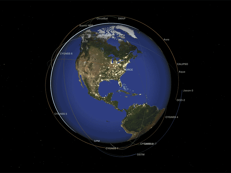
NASA is an exploration agency, and one of our missions is to know our home. We develop novel tools and techniques for understanding how our planet works -- for the benefit of humanity and for insights we need to explore other moons and planets. NASA's Earth Science Division operates more than 20 satellites in orbit, sponsors hundreds of research programs and studies, and funds opportunities to put data to use for societal needs. We develop new ways to observe the oceans, land cover, ice, atmosphere, and life, and we measure how changes in one drive changes in others over the short and long term. While listening to and collaborating with industry leaders, international partners, academic institutions, and other users of our data, we drive innovations and deliver science to help inform decisions that benefit the nation and the world.
Recent News and Articles

NASA’s Ready-to-Use Dataset Details Land Motion Across North America

NASA’s PACE Mission Reveals a Year of Terrestrial Data on Plant Health
NASA-French Satellite Spots Large-Scale River Waves for First Time

NASA, French SWOT Satellite Offers Big View of Small Ocean Features
Curious Universe Podcast's Earth Series
Welcome to Earth
There’s one planet NASA studies more than any other: Earth. With our unique vantage point from space, NASA collects information about our home in ways nobody else can. In this podcast miniseries, celebrate our home planet by learning how NASA studies Earth—including unique views of ocean color and sea level, land data that helps farmers improve crop production, and researching our atmosphere from the air we breathe to layers high above us that protect every living thing on the planet.

How NASA Sees Our Blue Marble
NASA is an exploration agency, and one of our missions is to know our home. In the 1960s, NASA astronauts orbiting the Moon captured a revelatory view of Earth. Today, NASA explores our home planet with a fleet of dozens of spacecraft. In this episode–the first in a miniseries all about Earth–we take in the view from space with Karen St. Germain, the director of NASA’s Earth Science Division.
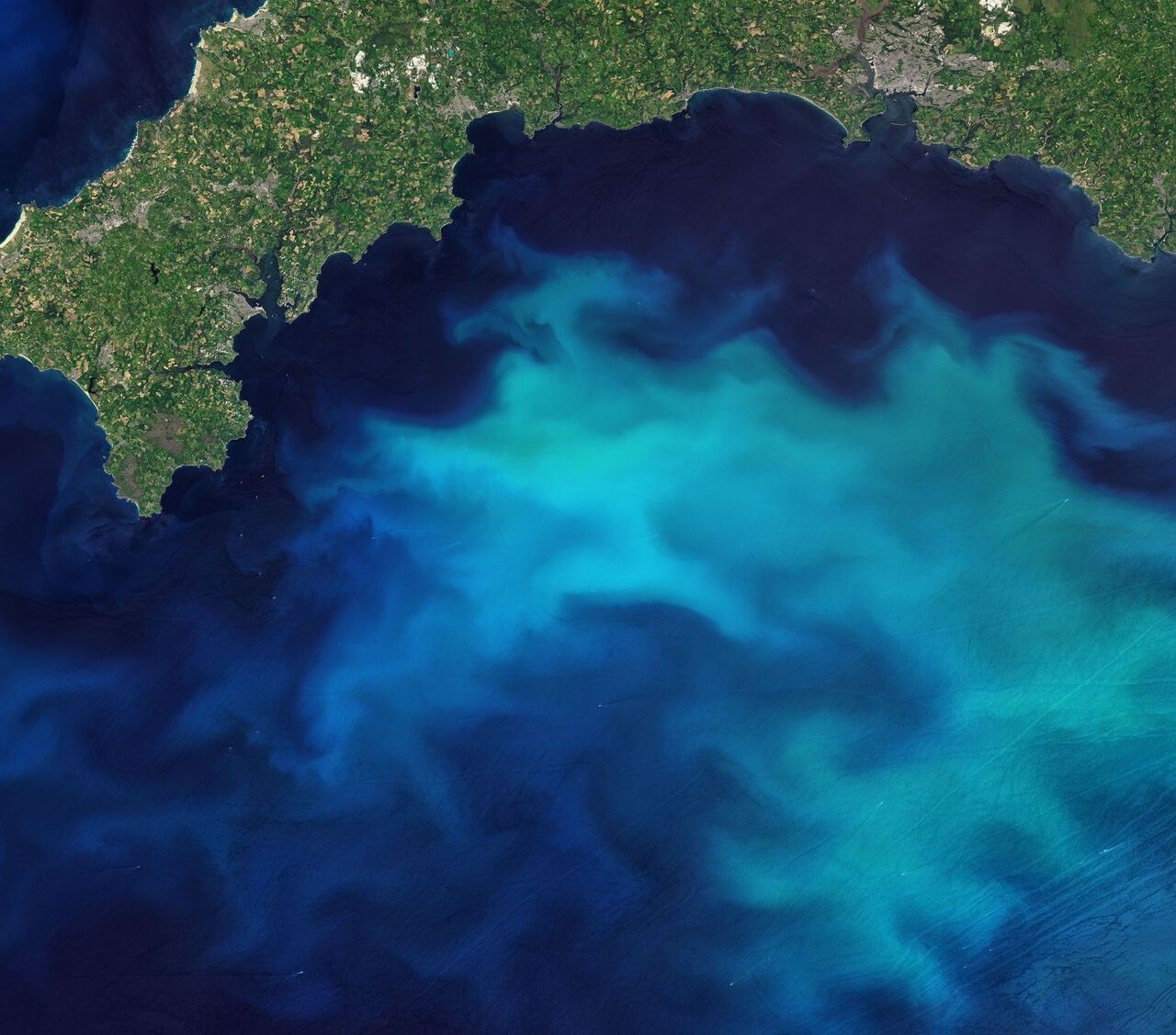
The Ocean, Now in Full Color
Life all over the planet—even far from the coasts—depends on the oceans. A pair of NASA satellites, PACE and SWOT, is giving us a fresh look at Earth’s water. PACE tracks color changes driven by tiny plankton, which give us a big-picture view of ocean life. By measuring sea level height from space, SWOT shows ocean currents and other features in new detail. NASA scientists Cecile Rousseaux, Kelsey Bisson, and Josh Willis dive into new research with a lot of color and a little bit of rock and roll.
From Space to Your Plate
Earth has an incredibly varied and ever-changing landscape—jagged mountains, arid deserts, lush rainforests, rolling wheat fields. Before NASA came on the scene, no one was keeping a systematic eye on the ground from above. NASA scientist Brad Doorn explains how one long-running satellite program collects the data farmers need to grow the crops that feed the world.
Monitoring the Air We Breathe
Take a deep breath, and you’re inhaling oxygen from Earth’s atmosphere. Take a walk outside, and the atmosphere is shielding you from harmful radiation. NASA research provides crucial data to understand air quality and the intricate processes happening in the sky above us. In this episode, hear the inside story of NASA’s research into the ozone layer. Left unchecked, our reliance on ozone-depleting chemicals threatened to expose the entire planet to dangerous UV radiation. We’ll also fly along with Laura Judd, a NASA scientist studying air quality in the U.S. and around the world.
What's Next For NASA Earth Science
NASA has a record of Earth observations going back more than 50 years. What might be in store for the next 50 years? In this finale of our Earth series, we hear from two scientists helping to chart the course of NASA Earth science. There are still many unanswered questions about our home planet. As the only planet that we know to have life, studying Earth is also crucial as NASA searches for other habitable worlds.
Science in Action for Society
Learn how NASA’s studies of Earth bring benefits to the nation and world.

NASA Data Helps Map Tiny Plankton That Feed Giant Right Whales

NASA Satellite Images Could Provide Early Volcano Warnings

NASA Uses Advanced Radar to Track Groundwater in California

FARMing with Data: OpenET Launches new Tool for Farmers and Ranchers

NASA Tests Drones to Provide Micrometeorology, Aid in Fire Response
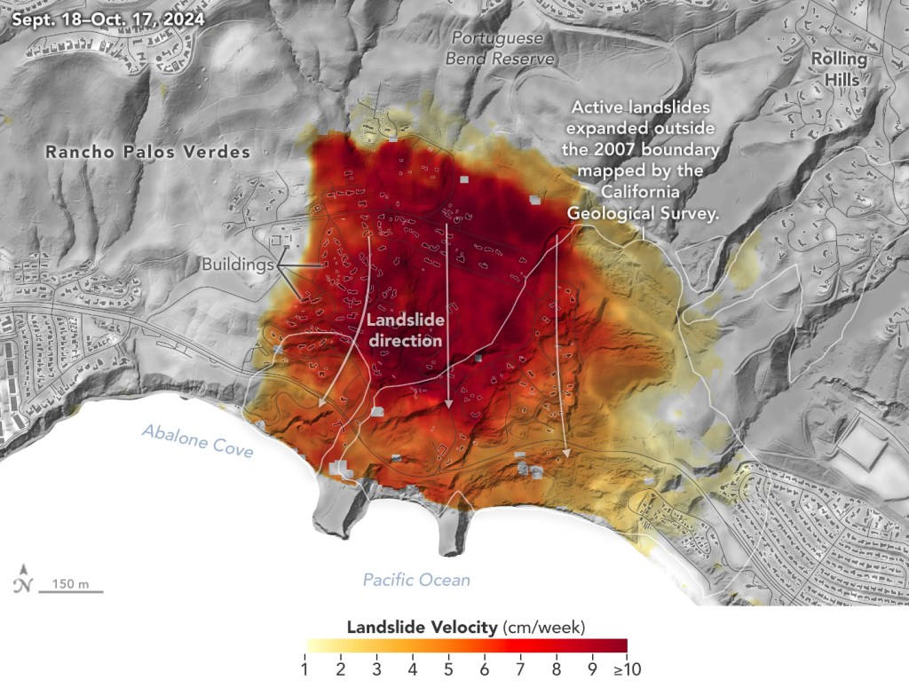
NASA Radar Imagery Reveals Details About Los Angeles-Area Landslides
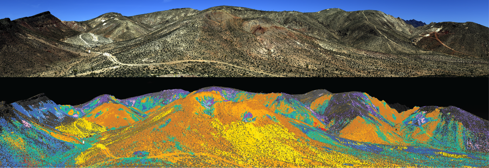
NASA Flights Map Critical Minerals from Skies Above Western US

NASA’s Brad Doorn Brings Farm Belt Wisdom to Space-Age Agriculture
Leaf Year: Seeing Plants in Hyperspectral Color
Researchers have now gathered a complete year of PACE data to tell a story about the health of land vegetation. PACE now allows scientists to see three different pigments in vegetation: chlorophyll, anthocyanins, and carotenoids. The combination of these three pigments helps scientists pinpoint even more information about plant health.
Watch on YouTubeSensing the Seas
For more than forty years, NASA has found unique ways to study the surface layers of the ocean from the tropics to the poles. With three new missions since 2020 – PACE, SWOT, and Sentinel 6-Michael Freilich – we are now ushering in a new era of ocean studies.

Next-Generation Water Satellite Maps Seafloor From Space

NASA’s PACE, US-European SWOT Satellites Offer Combined Look at Ocean


NASA Analysis Shows Irreversible Sea Level Rise for Pacific Islands

Surfing NASA’s Internet of Animals: Satellites Study Ocean Wildlife

NASA Wants to Identify Phytoplankton Species from Space. Here’s Why.

Picturing Earth: Astronaut Photography In Focus
For 20 years, astronauts have been shooting photos of Earth from the space station. Like everything the astronauts do, they are trained for this job. And like everything they do, there is purpose and intention behind it.
Images of the Day

A powerful weather system brought heavy snow to southern African mountains, plus high winds and flooding to the lowlands.

Field of Soy Dreams in Illinois
The Midwest state has flat land, fertile soils, and the nation’s largest soybean harvest.

Hurricane Barbara and Tropical Storm Cosme lined up off the western coast of Mexico.

A Tornado’s Mark on Kentucky
One of the strongest tornadoes to hit the area left a long scar across the landscape.

Two rivers diverge in a tropical rainforest of South America. And that has made some scientists do a double take.

Astronauts have photographed the diminishing lake in Central Africa for decades, most recently in January 2025, as its area remained just a fraction of its past size.

Geometry in the Golden Triangle
Agricultural fields in north-central Montana, where wheat grows in abundance, display captivating patterns when viewed from above.
Featured Story
Going With the Flow: Visualizing Ocean Currents with ECCO
NASA scientists and collaborators built the ECCO model to be the most realistic, detailed, and continuous depiction of the ocean ever developed. Read the story, watch the video, and look at the many new visualizations.
Read MoreEarth Information Center
For more than 50 years, NASA satellites have provided data on Earth's land, water, air, temperature, and climate. NASA's Earth Information Center allows visitors to see how our planet is changing in six key areas: sea level rise and coastal impacts, health and air quality, wildfires, greenhouse gases, sustainable energy, and agriculture.
Explore